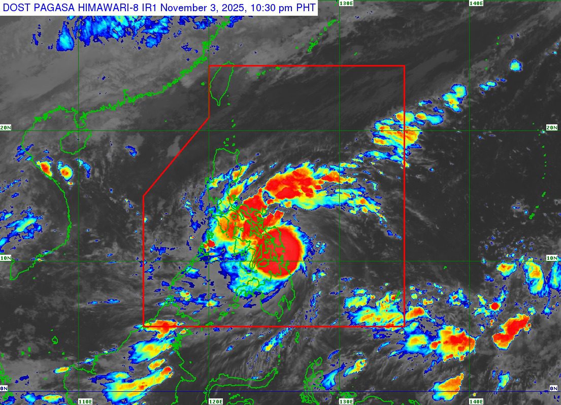



All real-time updates, advisories, and on-ground reports will be posted right here in this thread. Stay tuned and keep safe, Kapampangan!
End of Live Updates for #RamilPH
This concludes PN’s live coverage. Thank you for following our updates.
Status Report: Pampanga River Basin as of 5:00 PM, October 20, 2025

Tropical Storm Ramil Drenches Luzon: PAGASA Warns of Heavy Rains Through Monday
MANILA, Philippines — October 19, 2025 | 11:00 PM
Large portions of Luzon are bracing for another wet and windy night as Tropical Storm Ramil continues to bring heavy rains and potential flooding across northern and central provinces, according to PAGASA’s latest advisory.
From Sunday night until Monday evening (October 20), rainfall totals between 50 to 100 millimeters are expected in Ilocos Norte, Ilocos Sur, La Union, Pangasinan, Zambales, Bataan, Tarlac, Pampanga, Cavite, and Batangas. Forecasters warned that precipitation could be even higher in mountainous areas, where earlier rainfall has already saturated the ground—raising the risk of landslides and flash floods.
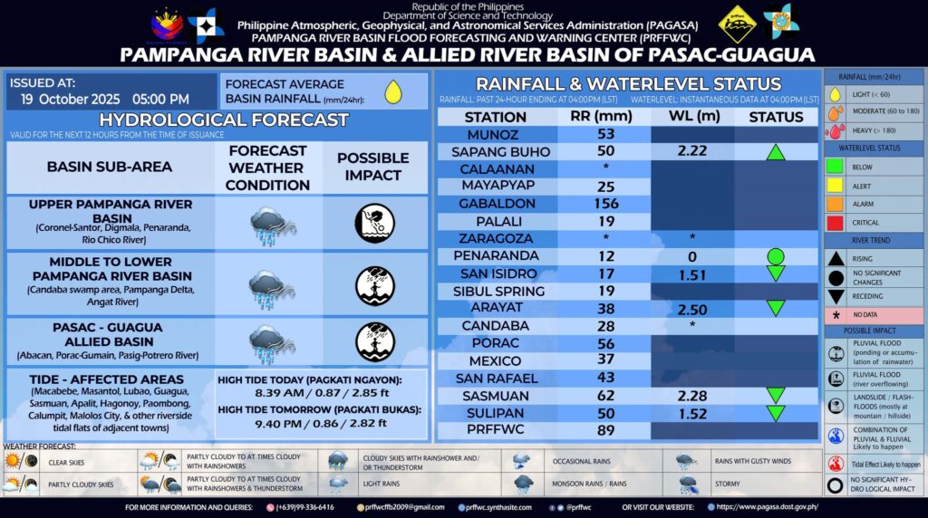
Pampanga River Basin Update — 5:00 PM, October 19, 2025
PAGASA Press Briefing via Zoom
Press Briefing via Zoom : Tropical Storm “RAMIL”{FENGSHEN} at 8:00 AM | October 19, 2025 – Sunday
DOST-PAGASA Weather Specialist : Leanne Loreto
Tropical Storm Ramil Moves Over Quezon, Brings Strong Winds and Heavy Rain
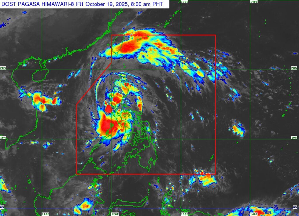
Metro Manila (October 19, 2025) — Tropical Storm Ramil (international name: Fengshen) continues to move west-northwest over the coastal waters of Quezon, bringing strong winds and heavy rainfall across several parts of Luzon, according to the latest weather bulletin from PAGASA.
As of 7:00 a.m., the storm’s center was located near the coastal waters of Mauban, Quezon, packing maximum sustained winds of 65 km/h near the center and gusts of up to 90 km/h. It is moving west-northwest at 20 km/h.
Strong to gale-force winds extend up to 430 kilometers from the center, affecting several provinces under tropical cyclone wind signals.
Areas Under Signal No. 2
Luzon provinces under Signal No. 2 — where gale-force winds may occur within 24 hours — include parts of Aurora, Nueva Ecija, Bulacan, Pampanga, Pangasinan, Quezon, Camarines Norte, northern Metro Manila, and several areas in Central Luzon.
Residents in these areas may experience minor to moderate impacts, including possible power interruptions, light structural damage, and fallen branches or debris.
Areas Under Signal No. 1
Signal No. 1 is raised over the rest of Metro Manila, CALABARZON, Bicol Region, and Northern Luzon, where strong winds are expected within 36 hours.
Rain and Flood Threat
PAGASA warns that Ramil will bring heavy rains over parts of Central and Southern Luzon. Residents in low-lying and mountainous areas are advised to remain alert for flooding and landslides.
Sea Conditions and Coastal Hazards
A Gale Warning remains in effect over both the eastern and western seaboards of Luzon, where waves could reach up to 4.5 meters. PAGASA strongly advises small vessels and fishing boats to stay in port due to dangerous sea conditions.
Meanwhile, a storm surge of 1 to 2 meters may occur along coastal areas of Aurora, Quezon, Camarines Sur, Zambales, Bataan, and Occidental Mindoro.
Expected Path
The storm is forecast to make landfall in Quezon Province this morning before crossing Southern-Central Luzon and exiting toward the West Philippine Sea by Monday. Once it leaves the Philippine Area of Responsibility, Ramil is expected to strengthen further into a severe tropical storm.
Authorities are urging the public and local disaster offices to remain vigilant and follow evacuation advisories when necessary.
The next update from PAGASA will be issued at 11:00 a.m. today.
Tropical Storm Ramil Maintains Strength While Moving Northwest Over Bicol Region
MANILA — Tropical Storm Ramil (international name: Fengshen) continues to move northwestward across mainland Bicol, maintaining its strength as it brings strong winds and heavy rains to several parts of Luzon and the Visayas.
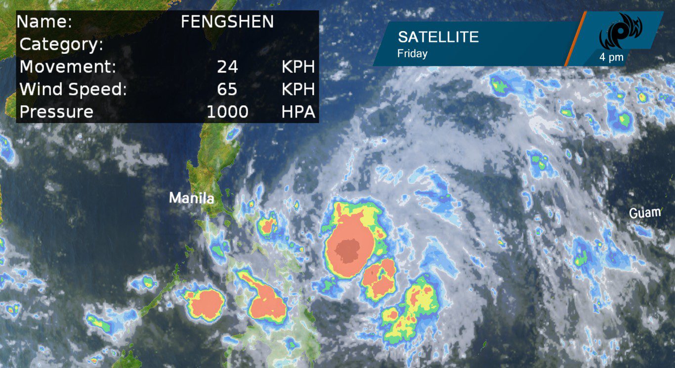
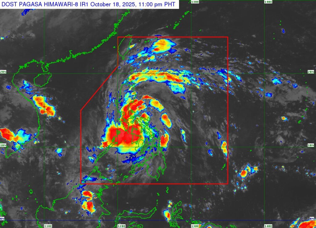
According to PAGASA’s 11 p.m. bulletin on Saturday, Ramil was last located over Calabanga, Camarines Sur, packing maximum sustained winds of 65 kilometers per hour near the center, gustiness of up to 110 kilometers per hour, and a central pressure of 1000 hPa. It is moving northwest at 25 kilometers per hour.
Strong to gale-force winds extend up to 400 kilometers from the storm’s center.
Tropical Cyclone Wind Signals Raised
Signal No. 2 is currently in effect in parts of Bicol, Northern Samar, and portions of Northern and Central Luzon, where gale-force winds may cause minor to moderate damage to life and property within 24 hours.
Signal No. 1 remains hoisted in surrounding areas including Cagayan Valley, the Cordillera region, Central Luzon, Quezon Province, and parts of Samar, where strong winds are expected within 36 hours.
Heavy Rainfall and Flooding Risks
PAGASA warned of heavy rainfall and potential flooding in affected areas, especially in regions under higher wind signals. Coastal flooding and storm surges reaching up to two meters are also possible along the eastern seaboards of Luzon, including Isabela, Aurora, Quezon, Camarines Norte, Camarines Sur, and Albay.
Sea travel remains risky, particularly for small vessels, as rough to very rough seas are expected in several coastal areas.
Forecast Track
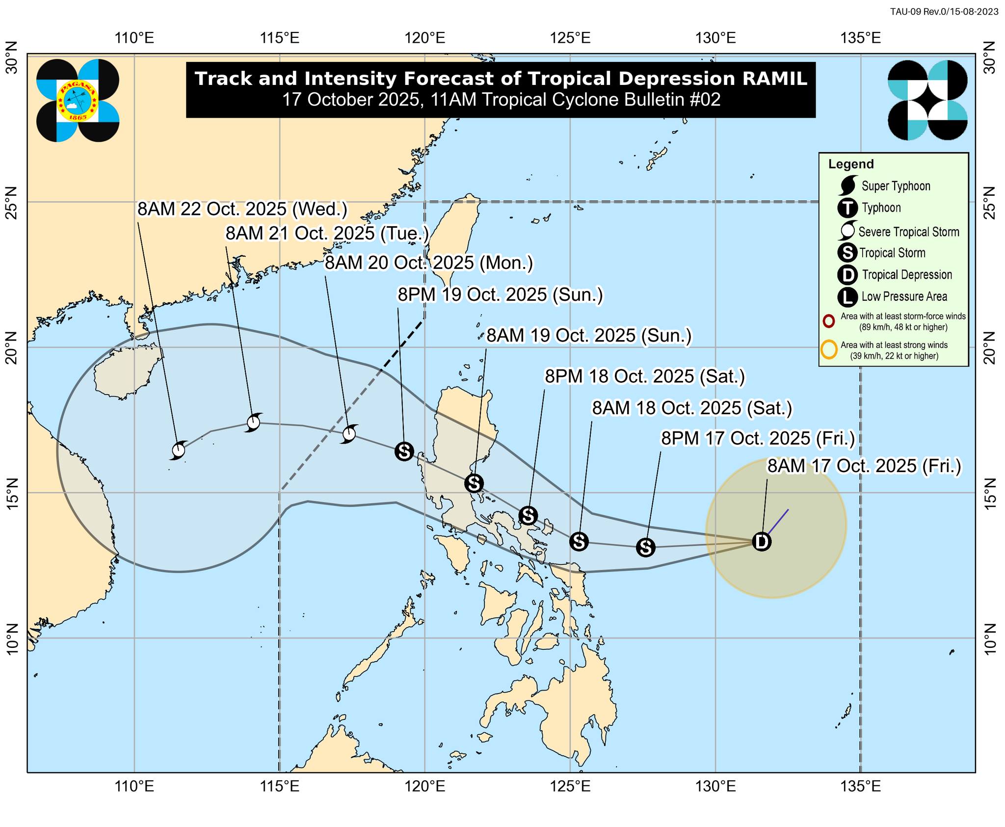
Tropical Storm Ramil is expected to continue moving northwest, crossing mainland Bicol overnight before emerging near the Polillo Islands early Sunday. It is forecast to make landfall in Aurora province by late morning or early afternoon. PAGASA noted that a possible shift in its track toward northern Quezon or southern Isabela cannot be ruled out.
After crossing Northern Luzon, Ramil is expected to exit the Philippine Area of Responsibility by Monday morning and could re-intensify into a severe tropical storm once it moves over the West Philippine Sea.
PAGASA urged residents in high-risk areas to remain alert, follow evacuation advisories, and stay updated on official weather bulletins.
The next advisory will be issued at 2 a.m.
Rescue Operations Underway in Roxas City as Floodwaters Rise Amid Tropical Storm Ramil
BFP/CDRRMO (Ronnie Dadivas) via Facebook
FLOOD ADVISORY NO.1 FOR PAMPANGA RIVER BASIN
ISSUED AT 6:00 PM, 18 OCTOBER 2025

PAGASA Press Briefing
Press Briefing : Tropical Storm “RAMIL”{FENGSHEN} at 5:00 PM | October 18, 2025 Saturday
Tropical Storm Ramil Weakens Slightly as It Moves Along Northern Samar Coast
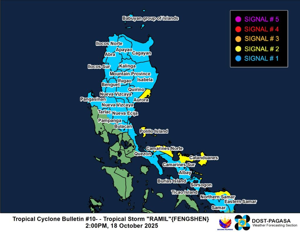
MANILA — Tropical Storm Ramil has slightly weakened while moving westward over the coastal waters of Laoang, Northern Samar, according to the latest update from state weather forecasters.
As of 1:00 p.m., the storm’s center was located near 12.7°N, 125.1°E, packing maximum sustained winds of 65 km/h near the center and gusts of up to 90 km/h. The system is moving west at 25 km/h, with strong to gale-force winds extending up to 400 kilometers from its center.
Signal Warnings Raised Across Luzon and Visayas
The weather bureau has placed several provinces under Tropical Cyclone Wind Signals (TCWS) due to the storm’s wide wind field.
Signal No. 2 is in effect over areas facing gale-force winds, including parts of Aurora, Camarines Norte, Catanduanes, Northern Samar, and portions of the Bicol Region. Residents in these areas may experience minor to moderate threats to life and property, with wind speeds ranging from 62 to 88 km/h within the next 24 hours.
Meanwhile, Signal No. 1 has been raised over large portions of Luzon and the Visayas, including Cagayan, Isabela, Pangasinan, Quezon, Camarines Sur, Albay, Sorsogon, and Eastern and Northern Samar. These areas may experience strong winds of 39 to 61 km/h within the next 36 hours, along with light to moderate damage risks.
Heavy Rainfall and Flooding Risks
Ramil continues to bring widespread rain to parts of Bicol, Eastern Visayas, and Southern Luzon. PAGASA warned that rainfall totals could be higher in mountainous and elevated areas, increasing the risk of flooding and landslides.
Residents in affected regions are advised to monitor the latest weather advisories and coordinate with local disaster risk reduction offices for evacuation and safety measures. Fisherfolk are also urged to stay onshore as rough to very rough seas are expected across eastern seaboards.
The public is advised to stay tuned for the next official update as Ramil continues to move closer toward Luzon, where it may bring more rain and gusty conditions in the coming days.
[ICYMI] Tropical Storm Ramil Expected to Make Multiple Landfalls; DA Warns of Crop Damage and Urges Farmers to Take Precautions
MANILA — Tropical Storm Ramil continues to move closer to the Philippines and is expected to make its first landfall over Catanduanes by Saturday afternoon (October 18), according to the latest forecast.
Weather models show that Ramil will track west-northwestward, passing close to or directly over the Bicol Region by Saturday evening. The system may then make another landfall over Aurora or Quezon by Sunday morning (October 19) before crossing the mountainous terrain of Northern or Central Luzon. It is expected to exit into the West Philippine Sea by Sunday afternoon or evening and leave the Philippine Area of Responsibility (PAR) by Monday (October 20).
Over 900,000 Hectares of Crops at Risk

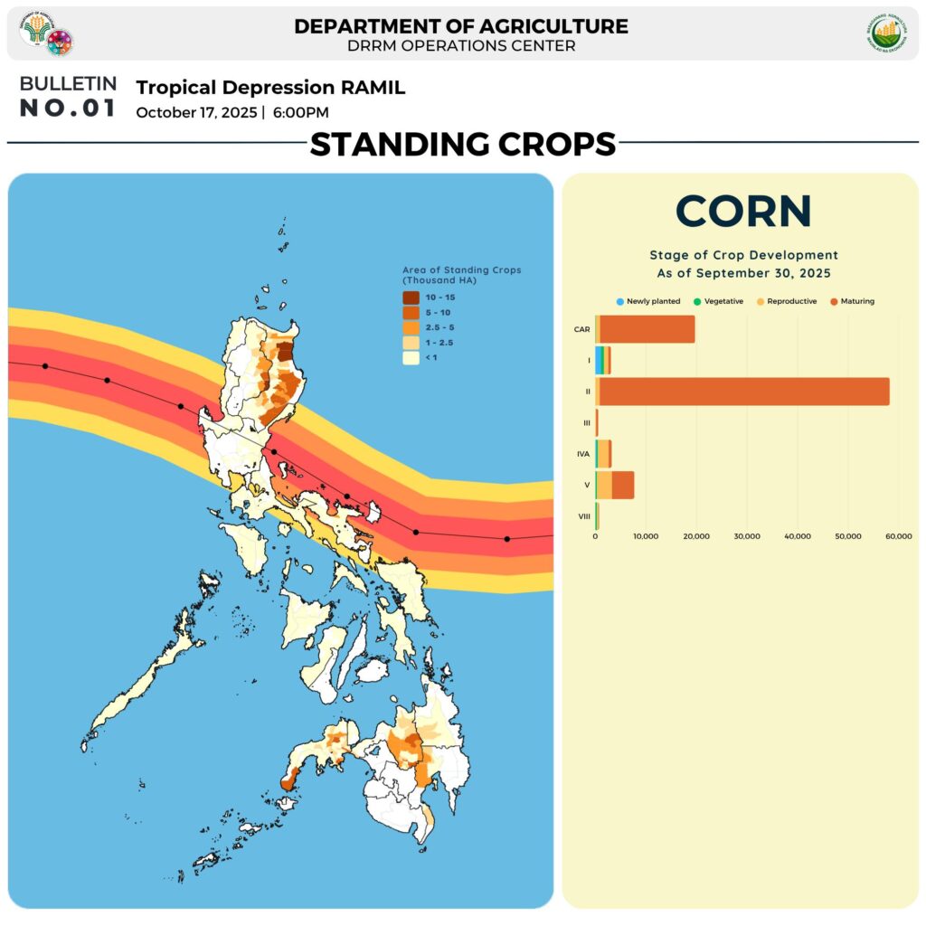
As of September 30, data from the Department of Agriculture (DA) shows that around 925,100 hectares of standing crops could be affected by Ramil.
This includes 831,821 hectares of rice and 93,279 hectares of corn located in the Cordillera Administrative Region (CAR) and Regions I, II, III, IV-A, V, and VIII.
Advisory for Farmers
The DA has urged farmers to take preventive measures ahead of the storm’s impact:
- Continuously monitor weather advisories and local warnings
- Harvest mature crops while conditions still permit
- Store seeds, fertilizers, and other inputs in secure, dry areas
- Move farm machinery and equipment to higher ground
- Prepare enough food and water for livestock that may need relocation
- Clear irrigation canals and paddies to prevent flooding and speed up drainage
Guidelines for Fisherfolk
The DA also issued safety reminders for those in the fisheries sector:
Follow local advisories and coordinate with coastal authorities for safety
Secure fish cages, ponds, and stocks; conduct early harvests if possible
Move boats and gear to safe locations on higher ground
Avoid sea travel as strong waves and rough conditions are expected
Photo and Data from Department of Agriculture
READ: Tropical Storm Ramil Slightly Intensifies as It Nears Northern Samar
MANILA — Tropical Storm Ramil (international name Fengshen) has slightly intensified as it moves closer to the coastal waters of Northern Samar, the state weather bureau reported late Saturday morning.
As of 10 a.m., the center of Ramil was located off the coast of Palapag, Northern Samar, carrying maximum sustained winds of 75 kilometers per hour (kph) and gusts reaching up to 90 kph. The system is moving west-southwest at 20 kph, with strong to gale-force winds extending up to 400 kilometers from its center.

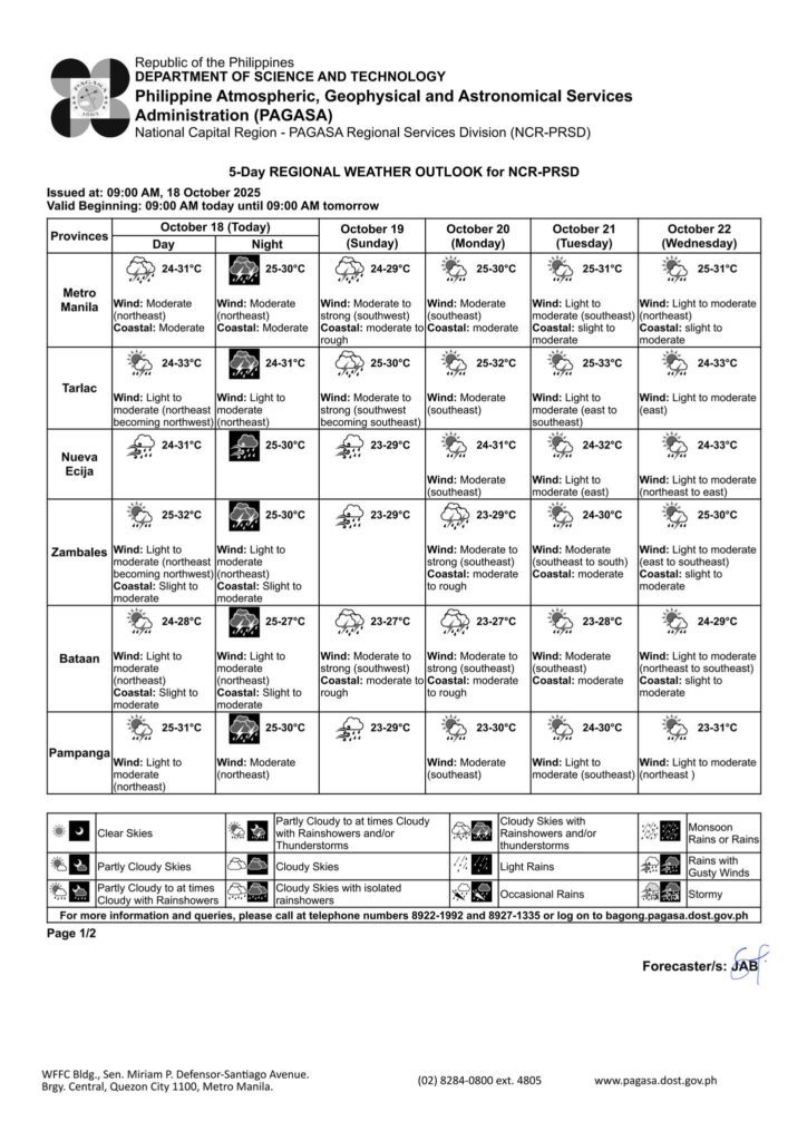
[Update] Regional Weather Outlook from PAGASA
PAGASA Press Briefing
Video courtesy of DOST PAGASA
Regional Weather Outlook from PAGASA
Issued at: 5:00 AM, 18 October 2025
Valid Beginning: 5:00 AM today – 5:00 AM tomorrow

 : DOST- PAGASA
PAGASA Rainfall Forecast – October 18, 2025
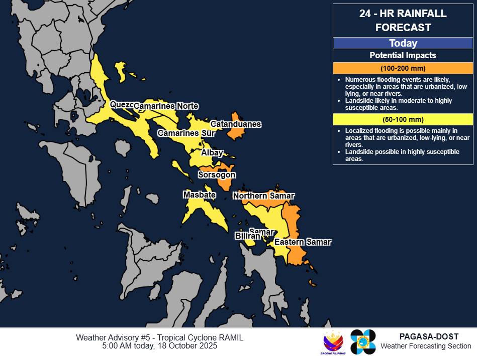
Photo by DOST PAGASA
ICYMI: Press Briefing for TS #RamilPH
Press Briefing via Zoom : Tropical Storm “RAMIL” at 5:00 AM | October 18, 2025 – Saturday
DOST-PAGASA Weather Specialist : Grace Castañeda
Video courtesy of DOST PAGASA / Facebook
RECAP: Tropical Storm Ramil Strengthens, Nears Landfall in Eastern Philippines
MANILA, Philippines — Tropical Storm Ramil, internationally known as Fengshen, has been upgraded by the Japan Meteorological Agency as it continues to move closer to the eastern coast of the Philippines, particularly near Samar and the Bicol Region.