


PampangaNews is activating its Live Blog for Tropical Cyclone #UwanPH
Tropical Cyclone Uwan Triggers Orange Rainfall Warning in Parts of Luzon — Flood Threat Remains
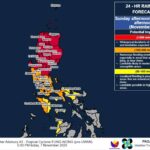
The state weather bureau has raised Heavy Rainfall Warning No. 4 over several provinces in Luzon as Tropical Cyclone Uwan continues to bring intense rains this Sunday afternoon, November 9, 2025.
At 2:00 PM, PAGASA placed Quezon, Laguna, Rizal, and portions of Bulacan (specifically Doña Remedios Trinidad and Norzagaray) under Orange Warning Level, indicating widespread flooding remains a serious threat in these areas.
Meanwhile, a Yellow Warning Level is in effect over:
- Nueva Ecija
- Metro Manila
- Cavite
- Batangas
- Bulacan (including Angat, Balagtas, Baliwag, Bocaue, Bulakan, Bustos, Calumpit, Malolos, Meycauayan, San Jose del Monte, Guiguinto, Hagonoy, Marilao, Obando, Pandi, Paombong, Plaridel, Pulilan, San Ildefonso, San Miguel, San Rafael, and Santa Maria)
- Pampanga (Arayat, Candaba, San Luis, Santa Ana, San Simon, Apalit, Magalang, Mexico, San Fernando, Santo Tomas, Minalin, Macabebe, Masantol, Bacolor)
- Tarlac (San Manuel, Paniqui, Moncada, Anao, Ramos, Gerona, Pura, Victoria, Tarlac City, La Paz, Concepcion)
Flooding remains possible in low-lying and flood-prone areas, PAGASA warned.
Light to moderate rains, with intermittent heavy downpours, are also affecting portions of Zambales, Bataan, and parts of Tarlac and Pampanga, a condition expected to persist for at least the next three hours.
Authorities urged the public and local disaster response units to closely monitor updates, stay alert for possible evacuations, and follow advisories. The next weather warning is scheduled to be issued at 5:00 PM today.
Residents are advised to remain vigilant as Tropical Cyclone Uwan continues its impact on Central Luzon and nearby provinces.
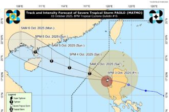
Flights to and from Clark Airport Cancelled as Severe Tropical Storm Fung-Wong Intensifies
CLARK FREEPORT ZONE, Philippines — Numerous flights to and from Clark International Airport (CRK) have been canceled as Severe Tropical Storm Fung-Wong continues to threaten parts of the country, based on the latest advisories from state weather bureau PAGASA.
As of 12:00 p.m., November 9, 2025, several airlines announced operational suspensions to ensure the safety of passengers and airport personnel.
CEBU PACIFIC / CEBGO
November 9:
• DG 6129/6130 — Clark–Naga–Clark
• DG 6171/6172 — Clark–Masbate–Clark
• DG 6355/6356 — Clark–El Nido–Clark
• DG 6357/6358 — Clark–El Nido–Clark
• DG 6295/6296 — Clark–Caticlan–Clark
• DG 6985/6984 — Clark–Cebu–Clark
November 10:
• DG 6129/6130 — Clark–Naga–Clark
• DG 6035/6036 — Clark–Coron–Clark
• DG 6037/6038 — Clark–Coron–Clark
• DG 6039/6040 — Clark–Coron–Clark
• DG 6355/6356 — Clark–El Nido–Clark
• DG 6357/6358 — Clark–El Nido–Clark
• DG 6359/6360 — Clark–El Nido–Clark
• DG 6759/6760 — Clark–Siargao–Clark
• DG 6763/6764 — Clark–Siargao–Clark
• DG 6963/6964 — Clark–Bohol–Clark
• DG 6985 — Clark–Cebu
PHILIPPINE AIRLINES / PAL EXPRESS
November 9:
• 2P 2696/2697 — Clark–Basco–Clark
• 2P 2875/2876 — Clark–Siargao–Clark
• 2P 2679/2678 — Coron–Clark–Coron
November 10:
• PR 2696/2697 — Clark–Basco–Clark
STARLUX
November 9:
• JX 791/792 — Taipei–Clark–Taipei
SUNLIGHT AIR
November 9:
• 2R990 — Siargao–Clark
• 2R833/2R834 — Caticlan–Clark–Caticlan
SCOOT
November 9:
• TR394/395 — Singapore–Clark–Singapore
AERO K
November 9:
• RF521/522 — Cheongju–Clark–Cheongju
Affected customers have been notified via email and may opt to rebook for free, convert to travel funds, or request a refund through their respective airline service channels.
Clark International Airport strongly cautions passengers not to proceed to the airport unless their airline has confirmed that their flight will push through.
CRK continues to advise travelers to remain alert and prioritize safety as the storm progresses.
“Stay prepared and travel smart with CRK — your safety is our top priority,” the airport advisory stated.
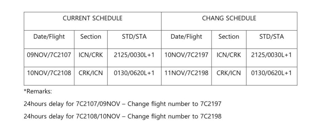
Jeju Air Suspends CRK–ICN Flights for 24 Hours Due to Typhoon Uwan
Clark, Pampanga— Jeju Air has issued a flight advisory announcing a full suspension of operations for the night involving flights between Clark International Airport (CRK) in the Philippines and Incheon International Airport (ICN) in South Korea, as Typhoon Uwan disrupts air travel across the region.
The airline confirmed that the affected CRK–ICN flights have been delayed for 24 hours. Passengers traveling to, from, or through the impacted airports are strongly advised to check their updated flight status before proceeding to the airport.
Jeju Air thanked passengers for their understanding and assured that safety remains the top priority as the powerful storm continues to pose risks.
Further announcements are expected as Typhoon Uwan continues its movement across affected areas. Travelers are encouraged to stay alert for updates.
Photo courtesy of Clark International Airport
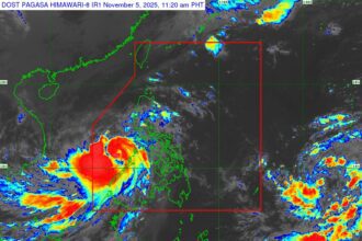
Storm Surge Warning Issued as Tropical Cyclone Uwan Approaches Philippines
The Philippine Atmospheric, Geophysical and Astronomical Services Administration (DOST-PAGASA) has issued Storm Surge Warning #05 as Tropical Cyclone Uwan threatens coastal communities across the country with a high risk of life-threatening storm surges over the next 48 hours.
Residents in low-lying coastal areas of several provinces are urged to brace for possible inundation caused by rising sea levels accompanied by powerful waves.
Storm Surge Height Estimates:
- Red Alert (Above 3 meters): Albay, Aurora, Cagayan, Camarines Norte, Camarines Sur, Catanduanes, Isabela, Pangasinan, Quezon, Sorsogon
- Orange Alert (2.1 to 3 meters): Cagayan, Camarines Sur, La Union, Northern Samar, Pangasinan, Quezon
- Yellow Alert (1 to 2 meters): Bataan, Bulacan, Cagayan, Cavite, Ilocos Norte, Ilocos Sur, Metro Manila, Pampanga, Zambales, Dinagat Islands, Surigao del Norte, Eastern Samar, Batangas
Recommended Precautionary Measures:
- Avoid coastal and beach areas
- Cancel all marine activities
- Evacuate to higher ground away from storm surge-prone zones
- Stay updated with the latest advisories from DOST-PAGASA
Disaster risk reduction and management offices are advised to implement appropriate emergency actions. The next storm surge update is scheduled for 2:00 AM on Sunday, November 9.
Approaching Tropical Cyclone UWAN Prompts Major Rainfall Alert Across the Philippines
MANILA, Philippines – Authorities have issued a serious weather alert as Tropical Cyclone UWAN continues its approach, threatening to unleash torrential rainfall across wide swaths of the Philippines over the next three days. Weather Advisory No. 6, released at 11:00 AM on November 8, 2025, details the severe heavy rainfall expected, urging immediate preparedness from the public and disaster response teams.
Immediate Threat: Luzon and Eastern Visayas Brace for Downpour
The most immediate and severe impact is forecast from today until noon tomorrow (November 9), with the Bicol Region expected to bear the brunt of the storm’s fury.
- Extreme Rainfall (>200 mm): Residents in Camarines Norte, Camarines Sur, Catanduanes, Albay, and Sorsogon must prepare for life-threatening flash floods and landslides.
- Heavy Rainfall (100-200 mm): Significant rainfall is also expected in Quezon, Masbate, Marinduque, Northern Samar, and Eastern Samar.
- Moderate Rainfall (50-100 mm): Areas including Bulacan, Rizal, Laguna, Romblon, Samar, and Biliran should also anticipate substantial rain.
Shift in Focus: Northern and Central Luzon Under Extreme Threat
The rainfall forecast shifts dramatically from tomorrow noon to Monday noon (November 10), placing the entire Northern and Central Luzon regions under an extreme rainfall threat.
- Extreme Rainfall (>200 mm): A vast area, including Ilocos Norte, Ilocos Sur, La Union, Pangasinan, the entire Cordillera Administrative Region (Apayao, Kalinga, Abra, Mountain Province, Ifugao, Benguet), Cagayan Valley (Cagayan, Isabela, Quirino, Nueva Vizcaya), Aurora, Nueva Ecija, Tarlac, and Zambales, is now on high alert for catastrophic flooding.
- Heavy Rainfall (100-200 mm): This extends to Metro Manila, Bataan, Pampanga, Bulacan, Cavite, Laguna, Batangas, Rizal, Quezon, and Occidental Mindoro.
- Moderate Rainfall (50-100 mm): Rainfall will also affect Batanes, Oriental Mindoro, Marinduque, Romblon, Camarines Norte, and Camarines Sur.
Lingering Rain Expected into Next Week
While the intensity is projected to lessen, significant rain will persist from Monday noon to Tuesday noon (November 11).
- Heavy Rainfall (100-200 mm): Benguet will continue to experience heavy rain, posing an elevated risk for landslides in its mountainous terrain.
- Moderate Rainfall (50-100 mm): Areas in Northern Luzon, including Batanes, Ilocos Norte, Ilocos Sur, La Union, Pangasinan, and Zambales, must remain vigilant.
Public Urged to Heed Warnings
The weather bureau stressed that actual rainfall amounts could be significantly higher, particularly in mountainous and elevated areas, and where ground saturation is already high from previous rains.
“The public and disaster risk reduction and management offices concerned are advised to take all necessary measures to protect life and property,” the advisory stated.
Regional services are expected to issue more precise Heavy Rainfall Warnings, Rainfall/Thunderstorm Advisories, and other severe weather information tailored to local conditions.
Crucial Distinction: The advisory clarified the difference between a broad, 24-hour Weather Advisory (which covers provincial-level outlooks) and the more precise, three-hour, municipal-level Heavy Rainfall Warning. While the Advisory provides a heads-up on potential danger, it should not be used as the definitive basis for official decisions like class suspensions, which require the real-time accuracy of the shorter-term Warnings issued by regional divisions.
The next Weather Advisory update is scheduled for 11:00 PM tonight, unless significant changes in the storm’s trajectory or intensity necessitate an earlier report.