


(Manila, Philippines) — Typhoon Tino, still a powerful weather system, has weakened slightly as it slows down over the Iloilo Strait Tuesday afternoon, according to state meteorologists.
The storm’s center was last tracked near the coastal waters of Jordan, Guimaras around 1 p.m. local time. Despite the downgrade in strength, Tino continues to pack maximum sustained winds of 130 kilometers per hour with gusts reaching 180 kph, and maintains a broad wind field stretching up to 300 kilometers from its eye.
Tino has shifted to a west-southwest motion at 20 kph and continues to impact several regions in Luzon and the Visayas. Officials warn that the system remains dangerous as communities face widespread flooding, destructive winds, and storm surge threats.
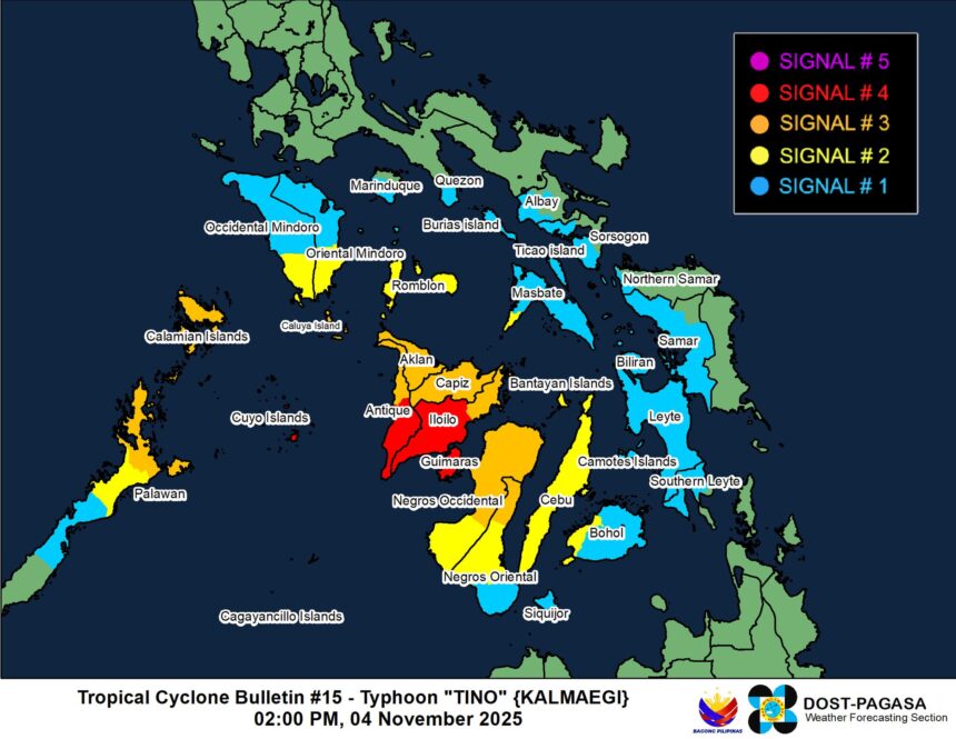
Widespread Wind Signals Raised
Emergency alerts remain in force across multiple provinces, including:
- Signal No. 4: Portions of Antique, Iloilo, and Guimaras in the Visayas, as well as Cuyo Islands, are facing life-threatening typhoon-force winds within hours.
- Signal No. 3: Storm-force winds affect Northern Palawan, Aklan, Capiz, parts of Negros Occidental and Negros Oriental, and surrounding islands.
- Signal No. 2 and Signal No. 1 areas stretch farther outward, covering portions of Southern Luzon, Cebu, Bohol, Eastern Visayas, and more, where gale-force and strong winds continue to increase risk to people and property.
Authorities warn that wind impacts vary depending on elevation and exposure to the storm’s direction, especially in coastal and mountainous zones.
Storm Surge and Marine Warnings
A dangerous storm surge exceeding 3 meters is possible along low-lying and exposed coastal areas in Palawan, Mindoro, Romblon, and Western Visayas. Residents in these areas are urged to move to higher ground and remain alert to local evacuation orders.
Seas across vast portions of the country remain perilous. Very rough to high waves — reaching up to 6 meters — pose extreme risk for all vessels. Mariners are advised to stay in port or seek safe harbor until conditions improve.
Track Update and Preparedness Measures
Typhoon Tino is expected to continue crossing Western Visayas before reaching northern Palawan tonight into Wednesday morning, eventually exiting the Philippine Area of Responsibility late Wednesday or early Thursday.
While weakening due to land interaction, Tino is likely to regain strength once it returns over the West Philippine Sea.
Government officials urge affected residents to monitor advisories, secure property, and prioritize safety. Local disaster response teams remain on heightened alert as rainfall, winds, and coastal hazards persist outside the immediate storm track.
The next advisory is expected later this afternoon as forecasters closely monitor Tino’s movement and intensity changes.