


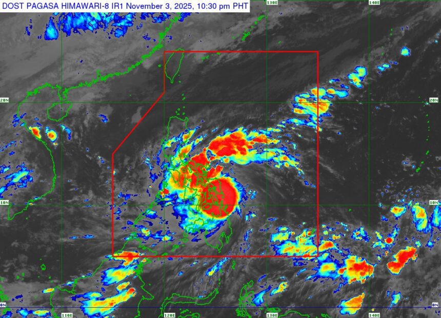
MANILA — A rapidly strengthening Typhoon Tino is now battering parts of Eastern Visayas, with severe winds and dangerous coastal conditions threatening communities in Homonhon and Dinagat Islands, according to the latest advisory from state meteorologists late Monday night.
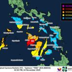
As of 10 p.m., the typhoon’s eye was tracked over coastal waters near Loreto, Dinagat Islands. Tino is packing maximum sustained winds of 150 km/h, gusts reaching up to 205 km/h, and continues to move west at 30 km/h. Authorities warn that the storm’s powerful winds extend up to 300 kilometers from its center, signaling widespread hazards across multiple regions.
Critical Wind Alerts Raised
The Philippine weather bureau has placed several provinces under high-level Tropical Cyclone Wind Signals, with Signal No. 4 indicating typhoon-force winds and a significant to severe threat to life and property. Areas under Signal No. 4 include parts of Eastern Samar, Leyte, Southern Leyte, northern Cebu, northeastern Bohol, northern Negros, Guimaras, Dinagat Islands, and Siargao.
Neighboring provinces from Visayas to Mindanao remain under Signal Nos. 3, 2, and 1, heightening expectations of destructive winds, additional flooding, and disruptions in the coming hours.
Landfall Expected Overnight
Forecasters expect Tino to make its first landfall between late Monday night and early Tuesday morning over Leyte or Southern Leyte. The typhoon will then track westward across the Visayas and northern Palawan before emerging over the West Philippine Sea by Wednesday, potentially exiting the Philippine Area of Responsibility by late Wednesday or early Thursday.
Although the storm may weaken slightly once over land, it is projected to remain a typhoon throughout its passage.
Widespread Coastal and Flooding Threats
Officials are responding to rising concerns about storm surge exceeding three meters, especially in low-lying communities across Western Visayas, Negros, Central and Eastern Visayas, Palawan, Mindoro, and Caraga Region. Gale warnings are in effect for most coastal waters, making sea travel extremely dangerous.
Residents in vulnerable areas are urged to evacuate and follow the guidance of local disaster agencies as worsening conditions are likely, even outside the immediate forecast track.
Authorities stress that threats from heavy rain, landslides, wind damage, and dangerous seas remain high. The next official bulletin will be released at 2 a.m. Tuesday, as Typhoon Tino continues its destructive advance across the country. Stay tuned to local alerts for region-specific advisories.